
| Sun | Mon | Tue | Wed | Thu | Fri | Sat |
|---|---|---|---|---|---|---|
| 1 | 2 | 3 | 4 | 5 | ||
| 6 | 7 | 8 | 9 | 10 | 11 | 12 |
| 13 | 14 | 15 | 16 | 17 | 18 | 19 |
| 20 | 21 | 22 | 23 | 24 | 25 | 26 |
| 27 | 28 | 29 | 30 | 31 |
CATEGORIES
RECENT ENTRIES
BLOG ROLL
On the map
|
|
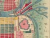
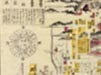
Call it the power of the Internet. In 1949 the University of California, Berkeley, bought the Mitsui family’s library, an extensive private collection of more than 100,000 items, including about 2,300 historical Japanese maps from the 17th through 20th centuries. In the half-century that these maps have lived at Berkeley’s East Asian Library, said Yuki Ishimatsu, head of the library’s Japanese Collections, in a campus lecture this past Friday, only seven people have physically viewed and handled them. But thousands have seen the maps online free of charge, thanks to the library’s digitization project. With help from David Rumsey Map Collection Cartography Associates, the library has scanned and put online some 900 of the maps so far. When the New York Times reported on the project in 2003, the Web site received more than 40,000 hits in three days.
Ishimatsu guided the audience through the Web site, demonstrating its functions and showing numerous examples of the four categories of maps: screen, scroll, city, and travel. Users can add notes and links to maps; save them to a file; and open up multiple maps simultaneously, comparing them side-by-side or superimposing one onto the other. By zooming in on the same spot in four different maps, a visitor can see how a given site has changed over the years. Within the next two or three months, users will be able to take advantage of a new feature: placing Japanese historical maps over Google Earth images.
As a librarian, Ishimatsu said, he sees it as his duty to provide scholars with interesting content. Librarians are like fishermen, he said, while scholars and researchers are like chefs, cooking the fish they find at the market for their colleagues and students. He hopes the Web site will both help academics by making these rare materials more readily accessible and increase general interest in Berkeley’s maps. “We’re very proud that this is open to the public,” Ishimatsu said. Perhaps that is why, though “many people have told me we should charge for this service,” the library continues to provide the images gratis, for anyone with an Internet connection.
Hana Yoo, ’07
Photo: 1877 pocket map (top). 1864 pocket map (bottom).
December 5, 2005