
| Sun | Mon | Tue | Wed | Thu | Fri | Sat |
|---|---|---|---|---|---|---|
| 1 | 2 | 3 | 4 | 5 | ||
| 6 | 7 | 8 | 9 | 10 | 11 | 12 |
| 13 | 14 | 15 | 16 | 17 | 18 | 19 |
| 20 | 21 | 22 | 23 | 24 | 25 | 26 |
| 27 | 28 | 29 | 30 | 31 |
CATEGORIES
RECENT ENTRIES
BLOG ROLL
Charting the unknown
|
|
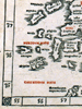
The European worldview fundamentally shifted in the late 15th century when Arabic and Byzantine traders brought copies of Ptolemy's Geographia to Italy, argues the Oriental Institute's exhibition, European Cartographers and the Ottoman World, 1500–1750: Maps from the Collection of O. J. Sopranos. The revival of Ptolemy's techniques, such as latitude and longitude lines, led to an explosion of attempts to reconcile ancient cartography with contemporary knowledge.
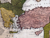
European mapmakers gradually incorporated travelers' accounts, sailors' maps, and geodetic survey data to create increasingly detailed political and physical maps. The development of these maps mirrors both the Enlightenment and the changing European balance of power, as first the Venetians, then the Dutch, French, and British made advances in mapping the Ottoman Empire.
The exhibit, part of the Festival of Maps, which presents map collections at libraries and museums throughout Chicago, runs through March 16, 2008. For more on the OI show, see the Nov–Dec '07 Magazine.
Ethan Frenchman, '08
Photos: Prima Asie Tabvla, Venetian Bernardus Sylvanus' 1511 revision of a map from Ptolemy's Geographia displays longitude and latitude lines; Englishman Herman Moll's 1720 map, The Turkish Empire in Europe, Asia & Africa, shows English interest in the Ottoman Empire.
Photos courtesy the Oriental Institute
November 16, 2007